Construction Site Monitoring: Methods, Costs & How Satellite Imagery Changed It (2026)
Every way to monitor a construction site in 2026 — inspectors, cameras, drones, and satellite imagery — with real costs, what each method actually proves, and how to build a monitoring stack that stands up to a lender, an auditor, or a lawsuit.
Construction site monitoring is the practice of systematically collecting evidence about what is physically happening on a job site over time — progress, activity, equipment, materials, safety, and security — and turning that evidence into decisions about money. In 2026 there are four mainstream ways to do it: send a person, mount a camera, fly a drone, or task a satellite. They are not interchangeable. Each one answers a different question, costs a different amount, and produces evidence of very different quality. This guide breaks down all four, what each one actually proves, what it costs, and how to combine them into a monitoring stack that holds up when a draw is disputed, a schedule claim is filed, or a loan gets sold.
Why construction site monitoring exists at all
Construction is one of the last major industries where the party spending the money usually cannot see what they are buying. A lender funds a $18M loan in 14 draws over 22 months, and each draw is approved based on paperwork the borrower assembled: a pay application, a schedule of values, lien waivers, and photos taken by someone on the borrower's payroll. Developers face the mirror-image problem — an owner or investor claims the project is late, and the only rebuttal available is the developer's own records. Monitoring exists to replace self-reported claims with independent, time-stamped, verifiable facts. Everything else — cost control, fraud prevention, schedule defense, insurance, safety — flows from that single shift.
Method 1 — in-person inspections
A third-party inspector visits the site, walks it, photographs it, compares what they see against the schedule of values, and issues a report. This is still the industry default for construction draw approval. What it proves: interior work, workmanship quality, material specifications, code compliance, and anything requiring physical presence. Nothing else on this list can see inside a building. What it costs: roughly $1,200–$3,500 per inspection depending on market, project size, and travel, which is why lenders typically buy them monthly at best. The weaknesses are structural rather than fixable: cadence is low, so a project can stall for five weeks before anyone notices; scheduling is coordinated with the borrower, so the site is prepared for the visit; and the evidence is a human narrative that can be argued with.
Method 2 — fixed jobsite cameras
A pole- or trailer-mounted camera with cellular uplink streams live video and time-lapse from a fixed vantage point. What it proves: continuous activity in one field of view, security and theft deterrence, dispute evidence for events inside frame, and excellent marketing time-lapse. What it costs: roughly $200–$600 per camera per month including connectivity and hosting, plus install; large sites need three to eight cameras for meaningful coverage. The weaknesses: coverage is limited to what the lens sees, cameras are blocked as structures rise, they are vandalized and stolen, they require power and a mounting point, and — crucially — they cannot be installed retroactively. If a dispute concerns work from eight months ago and no camera was mounted then, the footage does not exist.
Method 3 — drone surveys
A licensed operator flies a UAV on a programmed path, producing high-resolution orthomosaics, 3D point clouds, and volumetric measurements. What it proves: the highest spatial accuracy available short of survey-grade instruments — cut-and-fill volumes, stockpile quantities, as-built dimensions, roof and facade condition at centimeter resolution. What it costs: roughly $400–$1,500 per flight for a typical commercial site, and most projects fly monthly or at milestones. The weaknesses: it requires a local certified operator, airspace authorization near airports and controlled zones, a weather window, and site coordination — meaning drone flights, like inspections, are scheduled events the borrower knows about in advance. Cadence is bounded by cost and logistics, not by technology.
Method 4 — satellite imagery monitoring
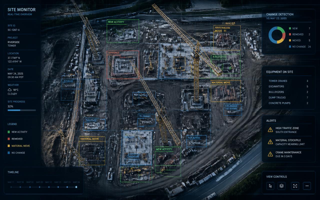
Earth-observation satellites capture the site from orbit on a recurring schedule, and change-detection software compares each new capture to the prior baseline to quantify what changed. What it proves: exterior, site-wide physical progress — land clearing, grading, excavation, foundation slabs, structural steel, roof deck, pavement, staging areas, equipment presence, and stockpile changes — plus an unbroken chronological record that cannot be back-dated because the capture timestamps belong to the satellite operator, not to any party in the transaction. What it costs: roughly $149–$199 per site per month for a full monitoring service including captures, AI change detection, and automated reporting. The weaknesses are honest and worth stating: satellites cannot see interior work, resolution limits detail to features larger than roughly a shipping container at the free public tier, and heavy cloud cover can delay a capture by a few days.
The resolution question, answered plainly
The most common objection to satellite monitoring is 'you can't see anything at 10 meters per pixel.' What 10m Sentinel-2 imagery reliably resolves: cleared and graded land, excavation footprints, poured slabs and foundations, structural steel frames, roof decks, paved surfaces and parking, laydown yards and material stockpiles, tower cranes, and heavy equipment. What it does not resolve: individual workers, window and door installation, drywall, MEP rough-in, or finishes. Commercial imagery at 30–50cm resolves vehicles, individual equipment types, and roof condition when a specific moment needs detail. The practical implication is simple: satellite monitoring is the right tool for phase-level exterior progress and continuity of record, and the wrong tool for interior verification. Those are different jobs.
Cost comparison over a real loan term
Take a 22-month construction loan on a mid-size commercial project. Monthly third-party inspections at $1,800 each: about $39,600. Monthly drone flights at $900: about $19,800. Four jobsite cameras at $350/month: about $30,800. Satellite monitoring at $199/site/month: about $4,378. The point is not that satellite monitoring replaces the others — it cannot see inside a building. The point is cadence economics. Satellite is the only method cheap enough to run continuously on every site in a portfolio, which makes it the correct baseline layer, with expensive high-detail methods triggered by what the baseline flags rather than by the calendar.
What continuous monitoring catches that periodic monitoring misses
Periodic monitoring samples; continuous monitoring observes. The difference shows up in four specific failure patterns. Silent stalls: a project stops and the next scheduled inspection is 30 days out, so 30 days of funded draws move against a static site. Continuous capture flags zero change after two consecutive weeks. Phantom progress: a draw claims a completed milestone that does not exist; a chronological imagery record makes the claim immediately falsifiable. Equipment theater: excavators and cranes appear the week of an inspection and vanish after — a pattern that only shows up when you look at every week, not the scheduled ones. Sequence violations: framing claimed before the slab appears, which is impossible and obvious in a time series. Across the market, projects that stall are typically identified four or more weeks earlier under continuous monitoring than under periodic inspection reports.
Construction site monitoring for lenders
The lender's use case is draw verification and portfolio risk. Workflow that works: enable monitoring at loan close so the baseline predates any work; on each draw request, pull the capture nearest the pay application's through-date; confirm the observed phase and percent change support the claimed milestone; fund; archive the imagery and change report in the loan file alongside the lien waivers. Reserve in-person inspections for interior-heavy phases and for any draw where imagery and paperwork disagree. Portfolio managers overseeing 100+ active loans get the largest gain: a single dashboard color-coded by progress velocity turns a week of report-reading into an exception-review session, and one lender running a $1.4B construction portfolio cut weekly review from 12 hours to 45 minutes on exactly this pattern.
Construction site monitoring for developers and GCs
Developers use monitoring defensively. When an owner alleges delay, an independent weekly imagery record with third-party timestamps is far stronger evidence than internal daily logs, because it was not produced by the party benefiting from it. The same record supports delay and acceleration claims, documents differing site conditions on the date they appeared, and proves weather-day impacts. It also removes friction from the draw cycle: a developer who attaches an independent progress report to every draw request tends to get funded faster and argued with less. For GCs and self-perform teams, monitoring validates schedule updates without pulling superintendents off the work to produce documentation.
Construction site monitoring for asset managers, insurers, and risk teams
Fund and asset managers monitor geographically dispersed portfolios without travel, and use progress velocity as an early distress signal months before financial reporting reflects it. Insurers use pre-loss imagery to establish site condition before a storm and post-event captures to triage claims within 48 hours; radar (SAR) imagery maps flood extent through cloud cover when optical satellites are blind. Underwriters use it to confirm that the risk described in an application matches the risk on the ground — including whether construction has actually started on a builder's-risk policy.
Security and safety monitoring is a separate problem
Theft, trespass, and safety compliance are real monitoring needs, but they are near-real-time problems with a human-scale field of view, which means cameras, on-site security, and sensor systems — not satellites. Site theft costs the U.S. construction industry an estimated $1B+ annually, and the effective countermeasures are lighting, access control, equipment telematics, and monitored cameras. Do not expect a progress-monitoring stack to solve a security problem, or vice versa; buy each for what it does.
How to build a construction site monitoring stack
Layer 1, continuous and universal: satellite monitoring on every site, every week, for baseline progress and exception detection. Layer 2, targeted: in-person inspections at interior-heavy phases and whenever Layer 1 flags an anomaly or a draw is contested. Layer 3, precision: drone flights at earthwork and closeout milestones where volumetrics or as-built accuracy carry money. Layer 4, site-specific: cameras where security, live coordination, or marketing time-lapse justifies the install. Then define the exception rules that trigger escalation — no change for 14 days, claimed phase not observed in imagery, equipment disappearance, or a draw request that outruns observed progress — and route each to a named owner with a deadline. A monitoring stack without written escalation rules is just an archive.
Evidence quality: what actually holds up later
When a monitoring record has to survive a dispute, an audit, or a loan sale, three properties matter. Independence — was the evidence produced by a party with a financial interest in the answer? Immutability — can the timestamp be altered or the record be curated after the fact? Continuity — are there gaps a counterparty can exploit? Borrower-supplied photos fail all three. Inspector reports are independent but discontinuous and narrative. Camera footage is continuous but partial and retroactively unavailable. Satellite imagery is independent, timestamped by the operator, globally consistent, and continuous from the date monitoring begins — which is why it has become the spine of modern construction monitoring rather than a novelty layered on top of it.
Common mistakes
Starting monitoring mid-project, which forfeits the baseline that makes change detection meaningful — start at loan close or notice to proceed. Buying one-off imagery instead of monitoring, which is dramatically more expensive per capture because of minimum-order area pricing. Monitoring only the flagship project while the portfolio's risk hides in the small loans nobody reviews. Collecting evidence but never defining thresholds, so anomalies sit in an inbox. And expecting any single method to answer every question — the fastest way to be disappointed by construction monitoring is to buy one layer and grade it against all four jobs.
The bottom line
Construction site monitoring in 2026 is a stack, not a product, and the economics have inverted: continuous independent observation is now the cheapest layer, and expensive human verification is best spent on exceptions the cheap layer surfaces. If you fund, build, insure, or manage construction, the practical starting move is to put a continuous baseline under every site you have exposure to, write the escalation rules, and reserve inspectors and drones for the questions only they can answer.
How Terra Trace IQ does it
Terra Trace IQ is satellite-powered construction monitoring built for lenders, developers, asset managers, and risk teams. You drop a pin on a site; we schedule recurring captures (every 3–5 days on Starter, daily on Growth and Enterprise) fusing free Sentinel-2 and Landsat-9 data with sub-meter commercial imagery where detail is required. AI change detection compares each capture to the prior baseline, quantifies percent change, tags the construction phase, and flags anomalies like multi-week stalls or unexpected equipment removal. Every week you get an automated PDF progress report with annotated overlays, and portfolio users get a dashboard color-coded by progress velocity across every active site. Plans start at $199 per site per month, month-to-month, with branded reports, alerting, CSV/PDF exports, and a REST API for loan-management integrations on Growth and above. Request a demo and we will monitor your own active sites so you can compare our reports against what your inspectors told you.
FAQ
Frequently asked questions
What is construction site monitoring?
Construction site monitoring is the systematic collection of independent evidence about what is physically happening on a job site over time — progress, activity, equipment, and materials — so that funding, scheduling, and risk decisions are based on verified facts instead of self-reported paperwork. It is performed with in-person inspections, fixed cameras, drone surveys, satellite imagery, or a combination of all four.
How much does construction site monitoring cost?
Third-party in-person inspections run roughly $1,200–$3,500 per visit. Drone surveys run roughly $400–$1,500 per flight. Fixed jobsite cameras run roughly $200–$600 per camera per month. Satellite monitoring services run roughly $149–$199 per site per month including recurring captures, change detection, and automated reports, which makes it the only method economical enough to run continuously on every site in a portfolio.
Can satellite imagery monitor construction progress accurately?
Yes, for exterior site-wide progress. At 10m resolution you can reliably see clearing, grading, excavation, foundation slabs, structural steel, roof deck, pavement, stockpiles, cranes, and heavy equipment — enough to confirm the construction phase and quantify week-over-week change. It cannot see interior work such as MEP rough-in or finishes, so interior-heavy phases still warrant an in-person inspection.
Is satellite monitoring better than drones for construction sites?
They solve different problems. Drones give centimeter-level detail and volumetric accuracy but require a local operator, airspace clearance, and a weather window, so they are used monthly or at milestones. Satellites capture continuously and globally at lower resolution with no site coordination, which makes them the right continuous baseline. The strongest programs use satellite monitoring every week and trigger drone flights when precision measurements are needed.
How do lenders use construction monitoring to verify draw requests?
Enable monitoring at loan close so the baseline predates any work, then on each draw pull the capture nearest the pay application's through-date, confirm the observed phase and percent change support the claimed milestone, fund, and archive the imagery and change report alongside the lien waivers. Reserve in-person inspections for interior phases and for draws where the imagery and the paperwork disagree.
How quickly does monitoring detect a stalled project?
Continuous monitoring flags a stall after two consecutive captures with no measurable change — typically about two weeks. Under monthly inspection cycles the same stall often goes unnoticed for four to six weeks, during which draws can continue to move against a static site.
Can construction monitoring prevent draw fraud?
It closes the most common gaps. An independent, operator-timestamped imagery record cannot be back-dated or curated, so recycled progress photos, phantom milestones, equipment staged only for inspection days, and impossible build sequences all become visible. Paperwork controls like lien waivers prove payment and released rights; imagery proves the work behind them physically exists.
What does Terra Trace IQ provide?
Terra Trace IQ monitors any construction site worldwide with recurring satellite captures (every 3–5 days on Starter, daily on Growth and Enterprise), AI change detection against the prior baseline, automated weekly PDF progress reports with annotated overlays, stall and milestone alerts, and a portfolio dashboard color-coded by progress velocity. Plans start at $199 per site per month, month-to-month, with branded reports, exports, and a REST API on higher tiers.
Pricing
Start monitoring your sites this week
Month-to-month plans, cancel anytime. Every plan includes weekly satellite captures, AI change detection, and automated PDF reports.
Starter
For lenders and developers monitoring a single active project.
- 1 active site
- Weekly satellite captures
- Automated PDF reports
- Email support
Growth
For portfolios of 2–25 active loans or projects.
- Up to 25 sites
- Daily captures + alerts
- Branded reports + API
- Portfolio dashboard
Enterprise
For institutional lenders, funds, and insurers at scale.
- Unlimited sites
- SSO / SAML
- Dedicated CSM
- Custom SLAs
A traditional in-person draw inspection costs $1,200–$3,500. Satellite monitoring delivers weekly verification for a fraction of that — see the full pricing page for volume discounts.